land surveying
How DJI Drone News Is Affecting Land Surveying
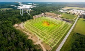
If you’re planning to buy land or start a project, you probably aren’t thinking about drones. Most people don’t. Still, recent news around DJI drones
If you’re planning to buy land or start a project, you probably aren’t thinking about drones. Most people don’t. Still, recent news around DJI drones
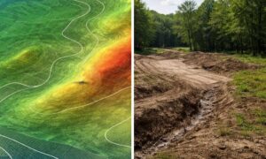
Public LiDAR mapping data is easy to find. A few clicks, and you can see elevation, slopes, and contours for land in Tupelo. Most people

If you plan to build, you may think your design is ready to go. You have your idea, your layout, and maybe even a contractor