Scroll through social media for five minutes, and you will likely see it. Two neighbors stand face-to-face, arguing about a fence. One claims the land. The other refuses to move. Voices rise. Cameras roll. Soon, the video goes viral. At first, these clips seem entertaining. However, they also reveal a serious problem. Many homeowners believe a fence marks their legal boundary. In reality, that fence often sits in the wrong place. When the truth comes out, emotions flare, and simple projects turn into major conflicts. This wave of viral property line wars highlights why working with a licensed land surveyor matters more than most people realize.
Why We Trust Fences, Trees, and Old Markers
Most people grow up thinking fences show property lines. That belief makes sense. After all, fences create visible borders. Over time, neighbors treat those borders as facts.
However, fences often go up for reasons that have nothing to do with legal boundaries. Some homeowners place fences for privacy. Others install them to keep pets in or wildlife out. Sometimes, people guess where the line runs and build accordingly. Years later, everyone forgets the original reason.
Trees, hedges, and ditches cause similar confusion. When land changes hands, new owners assume these features show where one property ends and another begins. Unfortunately, nature does not follow legal descriptions.
Because of this, visual clues rarely tell the full story.
How Small Projects Trigger Big Disputes
Many viral arguments begin with simple plans. A homeowner decides to build a new fence, widen a driveway, or clear brush. At first, the project feels routine. Then, the neighbor raises concerns.
Suddenly, questions arise. Does the driveway cross the line? Does the fence sit too far over? Did someone cut down trees that did not belong to them?
As tensions rise, both sides dig in. Each believes they are right. However, without accurate measurements, neither truly knows.
At this point, frustration grows. Family members get involved. Social media adds pressure. Legal threats appear. All of it could have been avoided with clear boundary information from the start.
What Actually Defines Your Property Boundary
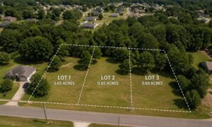
A legal boundary does not depend on fences, trees, or memory. Instead, it depends on recorded documents and precise measurements.
Property boundaries come from deeds, plats, and historical land records. These documents describe where each parcel begins and ends. However, reading and interpreting them requires training and experience.
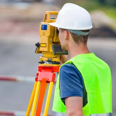
That is where a licensed land surveyor plays a key role.
Surveyors research property history, review legal descriptions, and locate physical markers placed decades ago. They use specialized equipment to measure distances and angles with high accuracy. After that, they piece together the evidence to locate the true boundary.
This process removes guesswork and replaces it with facts.
Why Property Line Conflicts Feel So Personal
Land holds deep meaning. For many families, it represents stability, heritage, and pride. When someone challenges that space, emotions rise quickly.
In addition, property often ties to major investments. Homes, barns, driveways, and fences cost money. When a boundary dispute threatens those investments, fear and anger take over.
As a result, even calm neighbors can clash.
This emotional side explains why property line arguments spread so fast online. Viewers relate to the stress. They picture themselves in the same situation. Suddenly, a simple fence becomes a symbol of fairness, trust, and respect.
The Real Costs of Getting It Wrong
Boundary mistakes carry real consequences. These go far beyond awkward conversations.
First, homeowners may need to remove fences, sheds, or additions that cross onto neighboring land. That work costs time and money. Next, legal disputes may follow. Attorneys, court filings, and settlements add even more expense.
Meanwhile, property sales can stall. Lenders hesitate when boundaries remain unclear. Buyers walk away. Deals collapse. Stress builds.
Even when conflicts resolve, relationships often suffer. Neighbors avoid each other. Tension lingers. The entire situation leaves lasting scars.
Fortunately, these outcomes remain preventable.
When to Call a Licensed Land Surveyor
Many people wait until problems start. By then, emotions already run high. Instead, smart homeowners act early.
Before building a fence, adding a driveway, or clearing land, it helps to confirm boundaries. Before buying or selling property, it also makes sense to verify lines. Even when inheriting family land, checking boundaries avoids future confusion.
A licensed land surveyor provides clarity. With clear measurements, homeowners move forward with confidence. They avoid surprises and protect their investments.
Most importantly, they preserve peace with neighbors.
Why Boundary Conflicts Appear Often in Northeast Mississippi
Tupelo and surrounding areas feature many older properties and rural tracts. Over time, land divides among family members. Farms convert into subdivisions. Roads expand. Record age.
As properties change, physical markers disappear. Old fence lines shift. Memories fade. All of this increases the risk of boundary confusion.
In these settings, relying on visual clues creates trouble. Instead, clear surveys offer the best protection.
A Common Real-Life Scenario
Imagine this. A homeowner buys a quiet property outside Tupelo. The yard looks clear. A fence runs along one side. Trees line the back.
Wanting privacy, the new owner installs a fresh fence based on the existing one. Weeks later, the neighbor complains. They claim the fence crosses the true boundary.
At first, the homeowner dismisses the concern. After all, the old fence stood there for decades. Still, tension builds. Both sides feel certain.
Eventually, they call a licensed land surveyor.
After careful research and measurements, the survey reveals the fence sits two feet inside the neighbor’s land. Although the error seems small, it changes everything. The homeowner must move the fence and repair damaged landscaping.
While no one enjoys this outcome, facts bring closure. The neighbors avoid court. Peace returns.
This type of story repeats often, both online and offline.
Clear Boundaries Protect More Than Land
At the heart of these viral disputes lies a simple lesson. Clear boundaries prevent conflict. They protect investments. They preserve relationships.
Working with a licensed land surveyor removes uncertainty. Instead of guessing, homeowners gain clarity. Instead of arguing, they rely on facts.
Before starting your next project, take a moment to verify your boundaries. That small step may save you stress, money, and heartache. In the end, peace of mind matters just as much as the land itself.